


Immediate Precautionary Orders Trigger Regionwide Slowdown
Local authorities across Western Visayas have executed a coordinated preemptive slowdown because Tino is moving rapidly toward national territory. Leaders suspended classes and professional operations early to reduce population exposure before structural risks fully materialize. Suspension timing aims to prevent last-minute congestion because delayed movement creates chaotic responses during storm inflection phases.
The Philippine Coast Guard has also begun curtailing maritime mobility to protect civilians. Vessel grounding ensures small passenger routes do not transform into casualty vectors if wave heights accelerate suddenly. Maritime regulators learned from earlier typhoon seasons that early bans prevent avoidable rescues once the storm centre enters the national corridor.
Storm Track Models Suggest Rapid Strengthening Next Week
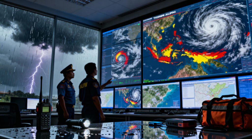
Pagasa guidance states Tino remains outside the Philippine Area of Responsibility for now, but trajectory simulations show an inbound path into the western sector. Multi-model ensemble data suggests the system will convert into typhoon category strength shortly after formal entry. Western provinces therefore operate under a time-compression environment because intensification can accelerate without visible warning.
Officials highlighted that storm category volatility often spikes immediately after warm-water contact near the regional band. This is why evacuation signalling has already been elevated even before maximum sustained wind upgrades occur. Communities near low-lying coastal zones are being instructed to remain monitor-ready because situational conditions may evolve within hours rather than days.
Households Reminded That Preparation Always Beats Reaction
Emergency agencies repeatedly emphasize that storms become most dangerous when individuals assume there is still time left. Families are encouraged to review evacuation bag inventory while road networks still function normally. The logistical objective is to move critical decisions forward rather than delaying them until the weather has already locked people in place.
Local utility teams also recommend securing mobile charging power banks, potable water, dry food stock, and protective coverings for exterior glass surfaces. Past cyclone cycles show that these basic steps significantly reduce injury risk and decrease pressure on emergency responders. Disaster readiness is only effective when executed before environmental deterioration begins.
Recommended Article: Cebu Tourism Strengthens Disaster Readiness for Recovery
Coordination Among Municipal Agencies Strengthens Response Efficiency
Capiz province activation orders represent a template for other municipalities expected to follow. Mutually aligned suspension protocols minimize transportation overlap issues and prevent inter-jurisdictional confusion during the first impact window. Authorities say unified messaging gives communities a clearer signal because fragmented notices historically produced hesitation.
Coast Guard spokespeople added that small island interlinks are the highest risk environment. Ferry captains are instructed not to negotiate marginal visibility or elevated swell charts. Strict enforcement aims to eliminate grey-area judgment decisions when the stakes are life preserving.
Residents Encouraged To Track Pagasa Advisory Frequency
Typhoon season dynamics remain nonlinear and every storm carries potential for abrupt course shifts. Pagasa bulletins remain the most credible reference because global models do not reflect micro-region geography nuances. Localized rainfall patterns can differ sharply from national maps due to terrain elevation and wind shear variables.
Citizens are urged to monitor official updates rather than social media speculation. False viral storm maps often spread quickly, creating confusion that distracts from legitimate evacuation messaging. Calm decision making remains achievable when information comes from verified national weather sources.
Community Leaders Warn Against Complacency During Pre-Typhoon Calm
Blue skies before land entry are not predictive indicators of safety. Residents frequently underestimate threat level when early daylight appears normal before evening structural intensification. Agencies want households to interpret the current window as a preparation gift rather than a reassurance sign.
Authorities say the next forty-eight hours will determine whether inland displacement protocols escalate. Preparedness culture is not just about stocking supplies — it is about eliminating rushed last-minute behaviour that generates preventable danger.
Final Advisory Reinforces Readiness As Primary Protective Mechanism
With Tino approaching the PAR boundary, Western Visayas communities operate inside an anticipatory posture. Officials want residents to assume that intensification is probable, not optional, because historical storm tracks consistently reward preparation and punish delay. That framing reduces harm even if intensity ultimately underperforms forecast.
Sea travel bans, school stoppages, and workplace suspensions are therefore not overreactions — they are the price of responsible risk-minimization. Storms test infrastructure resilience, but preparation tests human discipline. In this moment, disciplined preparation is the only rational strategy.